What Was on Your Street Before Your House Was Built?
Most homes in Culcheth, Lowton and Glazebury were built in the last 90 years. Before that, the land under them was farms, fields, a railway and, in one case, an orphanage. We've put the Ordnance Survey map of around 1905 next to today's, so you can see what your street replaced.
The Ordnance Survey revised its maps of this area around 1905, and the National Library of Scotland has put them online. Lay them next to a modern map and the villages are barely recognisable. Here's what was there, area by area. The old map is on the left of each picture and today's is on the right.
Culcheth was called Newchurch.
On the 1905 map, the name Culcheth belongs to the wider township and is written in big letters across the fields. The village itself is marked as Newchurch, clustered around the church and Common Lane. Twiss Green and Wigshaw are separate hamlets with farms between them. Culcheth Hall, home of the Withington family, sits in its own grounds to the north east. It was demolished after the Second World War, and Culcheth Hall Drive now runs through where it stood.

The railway ran straight through the middle.
The thick line cutting across the map is the Wigan Junction Railway, opened in 1884. Culcheth Station stood where the line crossed Wigshaw Lane, with the goods shed just along from it. Passenger trains stopped in 1964, the track went in 1968, and the station was demolished in 1977. The route is now the Linear Park, which is why it runs in such a straight line. Nearby, the map marks Kinknall Hall, Beech Mill and a little hamlet called Little London, all now under Wigshaw Lane and the roads off it.

The Linear Park runs in a straight line because it's a railway.
Stonyhurst Crescent is an orphanage.
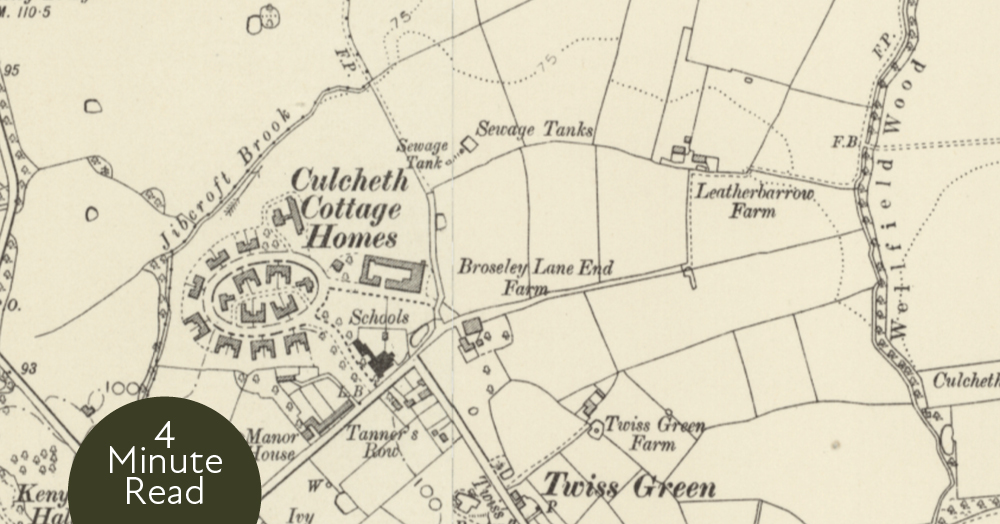
This is the one that surprises most people. At the top of Twiss Green, the map shows the Culcheth Cottage Homes: a ring of cottages around a green, with a school next door. The Salford Board of Guardians built them in 1903 to house children from the city's workhouses, with 24 cottages, a hospital and workshops. They closed in 1936, became Newchurch Hospital after the war, and were converted into private homes in the mid-1990s. Look at the modern map and the oval is still there. It's Stonyhurst Crescent, with Mitton Close inside it. Twiss Green Community Primary School stands almost exactly where the 1905 map says Schools.

The oval of cottages is still there. It's called Stonyhurst Crescent now.
Around it, every farm has become a road name or disappeared. Broseley Lane End Farm, Leatherbarrow Farm and Twiss Green Farm are all under houses. The sewage tanks marked north of the homes are under the newer estates off Doeford Close.
Lane Head had a toffee factory and no main road.
Lowton in 1905 is mostly fields with farms dotted along Church Lane. Stirrups Farm is now Stirrups Farm Road. Ashwood Farm is Ashwood Avenue. Fir Tree House is Fir Tree Avenue. Halfway down Church Lane, the map marks the Sovereign Confectionery Mills, complete with its own reservoirs. That was the Sovereign Toffee Works, and the Wigan archives still hold a photograph of its packing department. Lane Head itself had the Red Lion, the King's Arms and a smithy.
The most striking thing is what's missing. The East Lancashire Road isn't on the map because it didn't exist. It was opened by King George V on 18 July 1934 as the first purpose-built A road in the country, and it cut the village in two.

The East Lancashire Road isn't on the map because it didn't exist.
Lowton Common had its own railway junction.
North of the village, the St Helens branch of the Great Central Railway curves across the map, with Lowton Sidings and Lowton Junction marked beside it, and a brick works next door. Garton Common and Red House Farm are both still named on today's map. The sidings and the junction are now under Lowton Business Park and the estates around Hesketh Meadow.

Glazebury had a station on the world's first passenger railway.
The Liverpool and Manchester Railway opened in 1830, and Bury Lane station opened with it. It was renamed Glazebury and Bury Lane in 1878 and closed on 7 July 1958. The map shows it next to the Chat Moss Hotel, which is still there as The Glazebury. All Saints' Church, the cricket ground, Glazebury Mill, the Methodist chapel and the Raven Inn are all marked too, and Light Oaks Hall gives its name to Light Oaks Road.

Birchwood doesn't appear at all.
In 1905 the land that became Birchwood was the township of Risley: a scatter of farms, woods and mossland with no village to speak of. Garret Farm is now Garrett Field. Oak Wood Farm became Oakwood. There's a gamekeeper's lodge and an Old Fir Wood. In 1939 the government bought 927 acres of it for the Risley Royal Ordnance Factory, which filled bombs through the war, and after 1946 the site became the headquarters of Britain's atomic energy programme. The land was sold in 1968, and Birchwood was built on it through the 1970s. Birchwood Forest Park sits on the middle of the old factory site, and Ordnance Avenue remembers it.

Birchwood doesn't appear at all. In 1905 it was farms, woods and moss.
Look up your own street.
The National Library of Scotland's side-by-side viewer lets you put the old map next to today's for any address. Go to maps.nls.uk, choose Side by Side, and type in your postcode. If you find something interesting under your house, we'd love to hear about it.
Curious what your home is worth now, rather than in 1905? Call Sam on 01925 767000 or email sam@courtyardhomes.co.uk.